
1066 Harold’s Way is a 100 mile long distance walk, accessible by public transport, tracing a possible route of King Harold’s march from Westminster Abbey to Battle. It is based on the Roman road network still being used in 1066, from London to Rochester on Watling Street and then south through Maidstone, Staplehurst and Bodiam: a clear route through the daunting Forest of the Andredsweald. There are castles and battle sites, rivers, streams and valleys to cross, forests to forge and hills to climb, Roman roads, green lanes and ancient footpaths to walk.
For further information:
Long Distance Walkers Association

Palace of Westminster

Tower Bridge
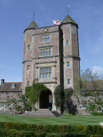
Sissinghurst Castle

Bodiam Castle
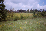
Site of Battle of Hastings with Battle Abbey in background
Automatically migrated from https://www.kentramblers.org.uk/KentWalks/harold/index.htm on 2025-12-11 10:54